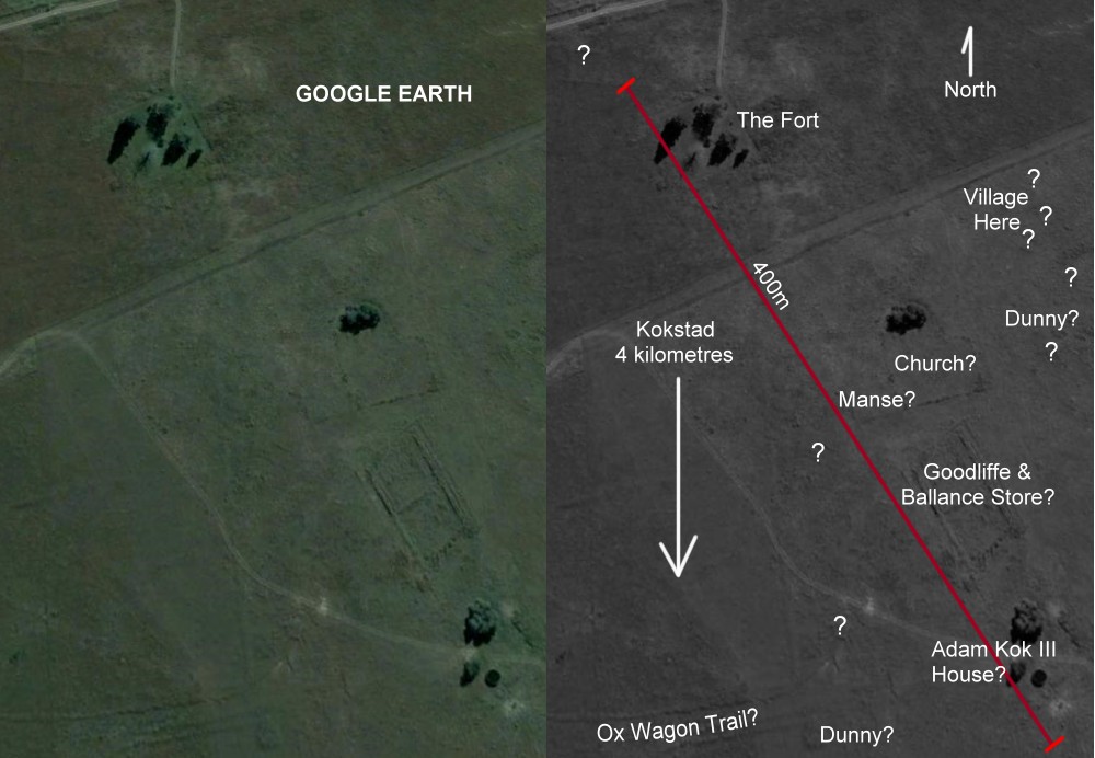
Google Earth again reveals hidden treasures
In the original Google Earth scan on the left of the 150 year old historic Griqua Mount Currie settlement you can see the distinct outline of the foundations of several old buildings. From ground level these foundations merge into the countryside and have never been identified before!
It is clear that these buildings are associated with this historic Griqua Settlement abandoned in the mid 1870s when the Griqua, under Adam Kok III, moved four kilometres to the south to the more sheltered town known as Kokstad.
In the grey edited scan on the right I have identified what these building could once have been - apart from the Fort, this is sheer speculation on my behalf. Until now only The Fort has been identified and a monument now marks the spot where it once stood. More images of The Fort taken by me in September 2006 can be seen at this link.

|
In A F Hattersley's LATER ANNALS OF NATAL records from the journal
of the Umzimvubu Prospecting Company's Expedition to Nomansland and Amapondoland dated 22nd July 1867: "To our disgust and disappointment we found it (the laager at Mount Currie) a very dirty place, consisting of about 200 mudhuts, a few old waggons, and a lot of dirty Griquas, sitting or lying outside their dens. A small church and a fort in the middle of the village and Adam Kok's house at one end. While we were in the store, one of Adam's daughters (or rather the "Princess Royal") came to purchase a bar of soap, and she certainly looked as though the money was well invested. Adding to the miserable appearance of the laager a number of houses half built and allowed to remain with their four walls standing. It is indeed, as one of our party called it, a village in ruins before it was built. After visiting a few stores and purchasing some necessary things for our larder, we passed through this wretched village and outspanned about four miles on the high road to Grahamstown.." This harsh account was written six years after the Griqua's devastating trek down the Ongeluksnek pass - see the video clip on the right for more. (Use full screen for best results) I have based my speculation of the position of the foundations of buildings on these records transcribed by Hattersley. The square building above the Fort is unidentified while the location of two dunnies (or toilets) is noted. Toilets make for fascinating archeological digs as proven by my 1970s dig in the F C Larkan token coin story In 2006 I visited Pilgrims Rest to uncover the old 1870s fort used by the boers in their war with the local tribes. Again Google Earth provided the key. More can be seen at this link
|
Hi Scott
What a fascinating find. One of the great frustrations of Griqua history is that there are so few first hand accounts of the Griqua settlement on Mount Currie. I have come across only three. The foundations that remain were obviously from better built and more substantial buildings. One presumes that the 200 mudhuts were not substantial enough to have foundations remaining after a 130 odd years. One can then speculate that more effort would have been put into building the church and the kaptyn's house and therefore these are the foundations that remain. I don't think that any one could dispute your identifications. Perhaps the building behind what was probably the church could have been Kok's house. Goodliffe & Ballance's store seemed to have been falling down even before the Griqua left. But again who could say? I think it would be a wonderful idea to under take a dig at the site. I dont know how we would go about it. We would have to get permision as it is a national monumnet. Perhaps the museum in Maritzburg would be intersted. When are you comimg out again. Perhaps a joint Kokstad Museum/ Natal Museum Scott Balson dig could be arranged. I will try later this week to go up and measure the foundations. Again what a wonderful find.
Regards
Milner